Article
From clifftop coastal paths to inland mountain trails, these are the seven hikes that capture the Algarve at its best — picked for variety, accessibility, and pure walking pleasure.
The Algarve Beyond the Beach
If you only know the Algarve from a beach holiday, you've been missing half of it. Beyond the resort coast lies a region of dramatic clifftops, quiet limestone plateaus, cork oak forests, and a 902m mountain — and it's all walkable, much of it on world-class waymarked trails.
These seven hikes give you the full range. From a 90-minute coastal classic that any reasonable walker can do, to a 300 km thru-hike that takes the truly committed three to four weeks. Mix and match based on your appetite and the season.
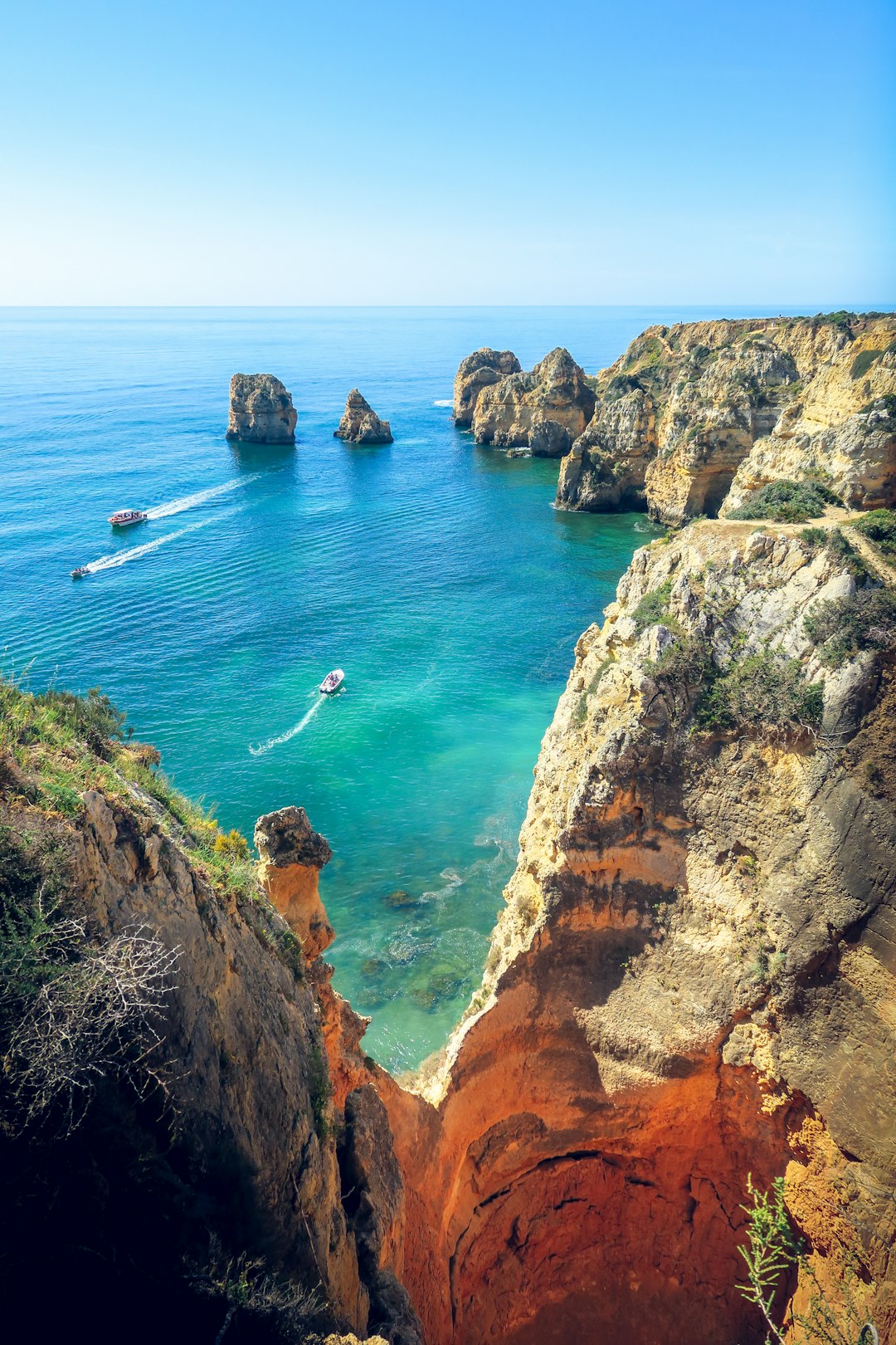
1. Seven Hanging Valleys Trail (Trilho dos Sete Vales Suspensos)
The Algarve's most famous coastal walk — for good reason.
- Distance: 5.7 km point-to-point (or 11.4 km return)
- Difficulty: Moderate
- Time: 2.5–3 hours one-way
- Trailhead: Praia da Marinha (east) or Praia de Vale Centeanes (west)
A clifftop path that strings together seven jaw-dropping coastal valleys, each carved into the limestone cliffs by the Atlantic. You'll pass arches, blowholes, and viewpoints over Praia da Marinha — repeatedly featured among the world's most beautiful beaches.
Best in: Spring or autumn (summer is hot and crowded; winter days are short but pleasant).
2. Rocha da Pena Loop
A flat-topped limestone massif in the Barrocal — wildflowers, vultures, and 360° views.
- Distance: 4.8 km loop
- Difficulty: Moderate
- Time: 2.5 hours
- Trailhead: Pena village, near Salir
The Algarve's interior at its best. The trail climbs onto the plateau, where griffon vultures and Bonelli's eagles ride the thermals overhead. In spring, the wildflowers are extraordinary. From the top: 360° views to Monchique in the west and the Atlantic to the south.
3. Fóia (Pico da Fóia)
Highest point in the Algarve, with views from sea to Spain.
- Distance: 13.8 km loop (PR1 MCQ) or drive to the top
- Difficulty: Hard for the loop / Easy if you drive
- Time: 5–6 hours hike / 25 minutes drive
- Trailhead: Monchique town
Fóia rises 902m above the Atlantic. On a clear day you can see Cape St. Vincent in the southwest, the Spanish border in the east, and the entire Algarve laid out below. The PR1 MCQ loop takes you up through eucalyptus and chestnut forests, mountain springs, and ridgelines — the full Monchique experience.
4. Praia do Barranco to Praia da Murração
A wild coastal walk on the Costa Vicentina — empty beaches, big skies.
- Distance: 9 km point-to-point
- Difficulty: Moderate
- Time: 3–4 hours
- Trailhead: Praia do Barranco
The west coast hits differently. This stretch on the Rota Vicentina's Fishermen's Trail crosses dunes, low cliffs, and three remote beaches between two parking areas. You can swim at most of them. There's almost no infrastructure, no crowds — just the Atlantic and you.
5. Ecovia do Litoral (Coastal Cycle/Walk)
A 214 km coastal trail from Cabo de São Vicente to the Spanish border — walk a section.
- Recommended section: Praia do Cabanas to Cacela Velha (~10 km)
- Difficulty: Easy
- Time: 2.5 hours
- Trailhead: Cabanas de Tavira (east) or Cacela Velha (west)
Tavira to Cacela Velha is the prettiest stretch of the Ecovia — flat, easy walking past the Ria Formosa lagoon, salt pans, and oyster beds. End in Cacela Velha, a postcard-perfect village on a bluff over the lagoon, for one of the best small lunches on the eastern Algarve coast.
6. Via Algarviana (Section: Alte to Salir)
A taste of the inland trail — cork oak, Barrocal, and traditional villages.
- Distance: ~15 km point-to-point
- Difficulty: Moderate
- Time: 4–5 hours
- Trailhead: Alte village
The Via Algarviana is the Algarve's east-west walking trail — 300 km from Alcoutim on the Spanish border to Cape St. Vincent. The Alte → Salir section is one of the most accessible, taking you through the rolling Barrocal countryside, cork oak forests, and into Salir's whitewashed centre.
7. Praia da Bordeira to Pontal da Carrapateira
A short coastal classic on the wild Atlantic west — beach, cliffs, dunes.
- Distance: 4 km loop
- Difficulty: Easy–Moderate
- Time: 1.5–2 hours
- Trailhead: Praia da Bordeira parking area
The kind of west-coast walk you'll think about for years. Wide empty beach, soft dune systems behind, then a clifftop section out to Pontal — a dramatic headland with 360° Atlantic views. Pair with a coffee in Carrapateira village.
Practical Tips
- Footwear: Proper hiking shoes, not trainers. The Algarve's stony paths and limestone are hard on cheap soles.
- Water: Always carry more than you think you need. Most trails have no fountains.
- Season: October–May is ideal. Avoid midday in summer (June–September).
- Sun: Hat, sunscreen, sunglasses — even in winter.
- Maps: All seven trails are well-waymarked. Pick up GPX tracks from viaalgarviana.org or trail apps like Wikiloc.
- Don't underestimate inland Algarve. It's wilder, quieter, and very different from the coast.
Where Next?
If this lit a spark, the Algarve has plenty more — including the full Via Algarviana (300 km, three to four weeks), the Rota Vicentina Fishermen's Trail (the full west coast), and dozens of less-known regional trails. The interior is where the Algarve gets really interesting.
Experience It Yourself
Book a guided experience in the Algarve
Algarve Wine Tour of Two Wine Estates
From €77
Benagil Cave - Sunrise or Sunset Kayak Tour (Small groups)
From €32
Algarve Tandem Skydive 15k ft (4600m)
From €219
About the Author
Active Algarve Team
9 min read
Sharing the best of the Algarve with our readers.
Places in This Guide
AlgarveGet the Algarve Insider
Weekly tips on hidden trails, local events, and experiences worth booking.
No spam. Unsubscribe anytime.
Related Guides
Discover more of the Algarve
Tavira & the Eastern Algarve: A 2026 Guide for People Who've Done Lagos
If you've done Lagos and Albufeira, the eastern Algarve is the obvious next trip. From a local — Tavira and the surrounding lagoon, islands and salt-flat country, with ferry times, market hours, and a day-trip to Spain.
UK Father's Day in the Algarve: A Weekend Plan for 21 June 2026
UK Father's Day 2026 falls on Sunday 21 June. Pre-school-holiday warmth, shoulder pricing, and Portuguese public holidays the same week make it the smartest weekend break of the early summer. Three real itineraries — golf-and-tasca, surf-and-sunset, supercars-and-Michelin.
The Algarve's Michelin Map 2026: Stars, Bibs and the New Alameda Faro Star
The 2026 Michelin guide added Alameda in Faro to the Algarve's starred list. Here's the full map — Vila Joya, Ocean, São Gabriel, Henrique Leis, Bon Bon, Alameda — with real-world booking advice, dress codes, prices in £, and the tasca counterpoints that locals actually book on a Tuesday.