Article
Discover the Algarve's most spectacular hiking trails, from dramatic coastal cliffs to mountain paths through cork oak forests. Complete guide with difficulty levels, distances, and practical tips.
The Algarve offers some of Europe's most rewarding hiking experiences, from dramatic cliff-top coastal walks to remote mountain trails through cork oak forests. With over 300 days of sunshine annually and mild temperatures year-round, this is a hiker's paradise. Here's your complete guide to the region's best trails.
Why Hike the Algarve?
- Perfect climate: Mild weather makes hiking possible year-round (best September to June)
- Diverse landscapes: Coastal cliffs, mountain ranges, river valleys, and protected wetlands
- Well-marked trails: Excellent signposting on most routes
- 40% protected: Much of the Algarve enjoys conservation status
- Rich biodiversity: Endemic plants, migrating birds, and varied wildlife
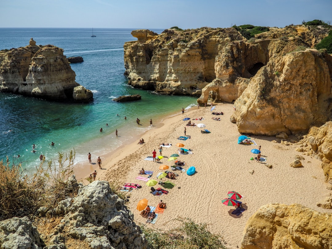
The Seven Hanging Valleys Trail (Percurso dos Sete Vales Suspensos)
Consistently rated among Europe's best coastal walks, this trail delivers jaw-dropping scenery from start to finish.
The Details:
- Distance: 11.4 km (out-and-back) or 5.7 km (one way)
- Duration: 4-5 hours (full trail) or 2-3 hours (to Benagil)
- Difficulty: Moderate
- Terrain: Cliff-top paths, some rocky sections
- Highlights: Seven "hanging valleys," views into Benagil Cave, golden limestone cliffs
Trailhead: Praia da Marinha car park (arrive early in summer)
What to Expect: The trail follows the cliff edge between Praia da Marinha and Praia de Vale Centeanes. You'll pass dramatic rock formations, hidden beaches, and the famous viewpoint above Benagil Cave. The seven valleys are dry riverbeds that end abruptly at the cliff edge, creating spectacular vistas.
Essential Tips:
- Bring at least 2 liters of water - no shade on the trail
- Start early morning to avoid crowds and heat
- Most hikers walk to Benagil and back (5.4 km total)
- Never approach cliff edges - erosion creates hidden overhangs
The Rota Vicentina: Fishermen's Trail
Part of one of Europe's great long-distance hiking networks, the Fishermen's Trail follows the wild western Algarve coast through the Costa Vicentina Natural Park.
The Details:
- Total Distance: 226 km (full trail into Alentejo)
- Algarve Sections: Multiple day stages from Sagres northward
- Difficulty: Moderate to challenging
- Terrain: Sandy paths, cliff tops, beach walking
- Highlights: Unspoiled beaches, dramatic cliffs, authentic fishing villages
Popular Day Stages:
Salema to Praia da Luz (12 km) A beautiful coastal walk passing Boca do Rio beach with Roman ruins, dramatic cliff scenery, and ending at the charming village of Luz.
Vila do Bispo to Sagres (17 km) Approaching the southwestern tip of Europe with views toward Cape St. Vincent. Wild, windswept landscapes.
Aljezur to Arrifana (10 km) Through rolling hills and cork oak forests to the surf town of Arrifana with its dramatic bay.
Trail Marking: Look for green and blue horizontal stripes on posts and rocks. The Historical Way (inland route) uses red and white marks.
Via Algarviana (GR13)
For serious trekkers, this 300-kilometer trail crosses the entire Algarve from east to west.
The Details:
- Distance: 300 km total, divided into 14 sections
- Duration: 14-21 days to complete
- Difficulty: Hard (multiple mountain sections)
- Terrain: Mountain paths, rural tracks, village roads
- Highlights: Serra de Monchique, Foia peak (902m), authentic villages
Route Overview: Starting in Alcoutim on the Guadiana River (Spanish border) and ending at Cape St. Vincent, the trail crosses three mountain ranges: Serra do Caldeirao, Serra de Monchique, and Espinhaco de Cao.
Best Sections for Day Hikes:
Stage 10: Alte to Sao Bartolomeu de Messines (22 km) Through traditional Algarve villages with whitewashed houses and the picturesque springs of Alte.
Stage 11-12: Monchique area Climb to Foia (902m) - the Algarve's highest point with panoramic coastal views.
Practical Information:
- Season: September to May (summer too hot)
- Book accommodation ahead - some villages have limited options
- GPX files available from viaalgarviana.org
- Trail is 90% cyclable for mountain biking
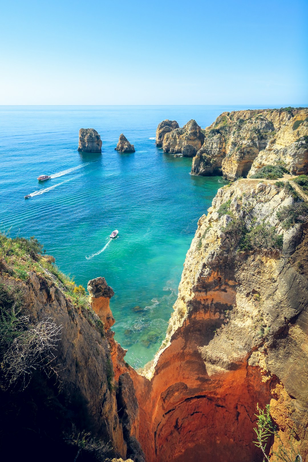
Ponta da Piedade Coastal Walk
A shorter but spectacular walk through Lagos' most dramatic coastal scenery.
The Details:
- Distance: 4-6 km (circular options available)
- Duration: 1.5-2.5 hours
- Difficulty: Easy to moderate
- Terrain: Cliff paths, some steps
- Highlights: Golden sea stacks, natural arches, hidden grottos
The Walk: Start from Praia do Camilo or Praia Dona Ana in Lagos and follow the cliff path to the Ponta da Piedade lighthouse. The rock formations here - sculpted by millennia of Atlantic waves - are among the Algarve's most photographed sights.
Combine With:
- Boat tour of the grottos from Ponta da Piedade (available on site)
- Kayak tour exploring the caves from below
- Swimming at one of Lagos' famous beaches
Rocha da Pena
A mountain hike offering dramatic cliff scenery and panoramic views inland.
The Details:
- Distance: 6.5 km (circular)
- Duration: 2.5-3 hours
- Difficulty: Moderate (steep sections)
- Terrain: Rocky mountain paths
- Highlights: 470m limestone plateau, natural spring-fed pool, endemic flora
The Route: Starting from the village of Rocha da Pena (near Querenca), the trail climbs to a dramatic limestone plateau. In spring, the area explodes with wildflowers. A natural pool near the base makes a perfect post-hike cooling spot.
Rock Climbing: Rocha da Pena is also the Algarve's premier sport climbing venue with nearly 100 routes on quality limestone (grades F4 to F8a).
Foia and Picota Peaks
Summit the Algarve's highest points in the Serra de Monchique.
Foia (902m):
- Distance: Various routes (4-12 km)
- Duration: 2-4 hours depending on start point
- Difficulty: Moderate to hard
- Highlights: Panoramic views to the coast, eucalyptus and cork oak forests
Drive or hike to Foia for views stretching to the coast on clear days. Multiple trails approach from Monchique town.
Picota (774m):
- Distance: 8 km (circular from Monchique)
- Duration: 3-4 hours
- Difficulty: Moderate
- Highlights: Less crowded than Foia, forest walking, ancient paths
Ria Formosa Nature Trails
Flat, easy walking through Portugal's most important wetland.
The Details:
- Various Routes: 2-10 km
- Duration: 1-4 hours
- Difficulty: Easy
- Terrain: Boardwalks, sandy paths, nature trails
- Highlights: Birdwatching, salt pans, island beaches
Best Starting Points:
Quinta de Marim (Official Park HQ) Environmental education center with marked trails and tide mill ruins.
Ludo Trail Follows the edge of the lagoon with excellent flamingo viewing (November-March).
Island Hopping: Take ferries from Faro or Olhao to Culatra, Armona, or Deserta islands for beach walks combined with lagoon exploration.
Seasonal Considerations
Best Months:
- March-May: Wildflowers, comfortable temperatures, green landscapes
- September-November: Warm but not hot, clear skies, fewer crowds
- December-February: Cool, occasional rain, but often excellent walking conditions
Summer Warning: July and August can exceed 35°C inland. If hiking in summer:
- Start before 7am
- Choose coastal trails with sea breezes
- Carry extra water
- Avoid midday sun entirely
Essential Hiking Gear
- Footwear: Trail shoes or light hiking boots (coastal paths can be rocky)
- Sun protection: Hat, sunscreen, sunglasses - there's little shade
- Water: Minimum 2 liters (more in summer)
- Navigation: Downloaded maps work offline; phone signal is generally good
- First aid: Basic kit including blister treatment
- Cash: Small villages may not take cards
Getting to Trailheads
Most trailheads require a car. Public transport options:
- Seven Hanging Valleys: Bus/taxi from Lagoa or Carvoeiro
- Rota Vicentina: Occasional buses between coastal villages
- Via Algarviana: Limited - taxi recommended for remote stages
Guided Options
For those preferring company or expertise:
- Multi-day tours: Several operators offer guided Via Algarviana and Rota Vicentina packages
- Day hikes: Local guides available for Seven Hanging Valleys and other popular routes
- Self-guided packages: Luggage transfers and accommodation booking included
The Algarve's trails offer something for every ability level - from gentle nature walks to multi-week expeditions. Pack your hiking boots and discover a side of Portugal's south that most visitors never see.
Experience It Yourself
Book a guided experience in the Algarve
Algarve Wine Tour of Two Wine Estates
From €77
Benagil Cave - Sunrise or Sunset Kayak Tour (Small groups)
From €32
Algarve Tandem Skydive 15k ft (4600m)
From €219
About the Author
Active Algarve Team
12 min read
Sharing the best of the Algarve with our readers.
Places in This Guide
AlgarveGet the Algarve Insider
Weekly tips on hidden trails, local events, and experiences worth booking.
No spam. Unsubscribe anytime.
Related Guides
Discover more of the Algarve
Tavira & the Eastern Algarve: A 2026 Guide for People Who've Done Lagos
If you've done Lagos and Albufeira, the eastern Algarve is the obvious next trip. From a local — Tavira and the surrounding lagoon, islands and salt-flat country, with ferry times, market hours, and a day-trip to Spain.

UK Father's Day in the Algarve: A Weekend Plan for 21 June 2026
UK Father's Day 2026 falls on Sunday 21 June. Pre-school-holiday warmth, shoulder pricing, and Portuguese public holidays the same week make it the smartest weekend break of the early summer. Three real itineraries — golf-and-tasca, surf-and-sunset, supercars-and-Michelin.
The Algarve's Michelin Map 2026: Stars, Bibs and the New Alameda Faro Star
The 2026 Michelin guide added Alameda in Faro to the Algarve's starred list. Here's the full map — Vila Joya, Ocean, São Gabriel, Henrique Leis, Bon Bon, Alameda — with real-world booking advice, dress codes, prices in £, and the tasca counterpoints that locals actually book on a Tuesday.