
About This Place
The windswept southwestern tip of Europe — where Henry the Navigator planned the voyages that reshaped the world. World-class surfing, dramatic Atlantic cliffs, and a wild end-of-the-earth atmosphere.
Sagres — The End of the Known World
Sagres sits at the southwestern corner of mainland Europe, on a wind-battered plateau above sheer Atlantic cliffs. For centuries, this was literally the end of the known world — the point beyond which maps showed nothing but sea monsters and the edge of the earth. That raw, elemental atmosphere still defines the place today.
Henry the Navigator and the Age of Discovery
Sagres is inseparable from the story of Prince Henry the Navigator (Infante D. Henrique), who established his base here in the early 15th century. Henry was obsessed with pushing beyond the known limits of navigation, and from Sagres he sponsored, planned, and financed the expeditions that would launch Portugal's Age of Discovery.
The debate about Henry's famous "school of navigation" at Sagres persists among historians. What's clear is that he gathered the best cartographers, navigators, astronomers, and shipbuilders of the age to this remote headland, creating a hub of nautical knowledge that fuelled decades of exploration. The voyages he launched from nearby Lagos — past Cape Bojador, down the African coast, and eventually around the Cape of Good Hope — reshaped the world map.
The Fortaleza de Sagres (Sagres Fortress) sits on the headland where Henry worked. Heavily damaged in the 1755 earthquake, the current walls are an 18th-century rebuild, but the scale of the headland itself is the real draw — sheer cliffs dropping over 70 metres to the Atlantic on three sides. Inside the fortress, a mysterious 43-metre stone Rosa dos Ventos (Wind Compass) is etched into the ground, its purpose still debated.
Cape St. Vincent
Four kilometres west of Sagres sits Cabo de São Vicente (Cape St. Vincent), the actual southwesternmost point of mainland Europe. The lighthouse here is one of the most powerful in Europe, visible up to 60 nautical miles at sea.
The cape has been a sacred site since pre-Roman times — the Romans called it Promontorium Sacrum (Sacred Promontory) and believed the sun hissed as it sank into the ocean here. Today it's a bleak, magnificent headland with a small market selling socks and sausages to tourists, which is one of those absurd details that makes Portugal endlessly charming.
The sunset from Cape St. Vincent, watching the sun drop into the open Atlantic from Europe's last point of land, is one of the great natural spectacles of the continent.
Surfing
Sagres punches well above its weight as a surf destination. The unique geography — a headland between the south coast and the west coast — means there's almost always a wave working somewhere nearby, regardless of swell direction or wind.
Praia do Tonel is the signature Sagres wave, sitting directly below the fortress on the western side. It's a beach break that can produce powerful, hollow waves, best on a north or northeast wind. Lifeguarded in summer.
Praia da Mareta is the town beach, more sheltered and better for beginners and longboarders on smaller swells.
Praia do Beliche — between Sagres and Cape St. Vincent — is a stunning cliff-enclosed beach with a consistent break, though access is down a steep path.
For more serious surf, the west coast beaches of Praia do Amado (30 min north) and Arrifana (40 min) are within easy reach and offer some of the most consistent waves in Europe.
Hiking
Sagres is the terminus of the Rota Vicentina, the long-distance trail network that runs down the Alentejo and west Algarve coast. The Fishermen's Trail ends (or begins) here, and the landscape is among the most dramatic on the entire route — raw clifftops, crashing waves, and virtually no development in sight.
The coastal walk from Sagres to Cape St. Vincent (about 8km) is one of the finest short hikes in the Algarve, passing along cliff edges with unobstructed ocean views the entire way.
Birdwatching
Cape St. Vincent is one of Europe's most important bird migration points. In autumn (September–November), raptors, storks, and passerines funnel through here on their way south to Africa. Birdlife International has designated the area as an Important Bird Area (IBA). Rare sightings include Egyptian Vultures and Bonelli's Eagles.
Practical Notes
Sagres is a small, quiet town — don't expect nightlife or a huge restaurant scene. It's a place for surfers, hikers, and people who like wind. The town has basic amenities, a few good restaurants clustered around the harbour, and a couple of surf shops.
Getting there: Sagres is about 1 hour west of Faro airport, or 30 minutes west of Lagos by car. There is a bus service but it's infrequent — a car is strongly recommended for exploring the area.
Getting Here
Weather & When to Visit
Hot and sunny with minimal rainfall. Peak tourist season with long days.
Sunshine
300+ days/year
Sea Temp
17–23°C
Tips for Summer
- Start outdoor activities early morning
- Stay hydrated and use sun protection
- Beach activities best before 11am or after 4pm
Best for this season
Best time to visit
April–June and September–October offer the best balance of pleasant weather, fewer crowds, and good prices.
Nearby Places
OdeceixeThings to Do in Sagres
Discover experiences, routes, and events

Stand Up Paddle Odeceixe River Tour
Provided on every activity : -Eco Board + hybrid carbon Paddle , Wetsuit + lifevest - quick introduction to stand up paddle and safety rules certified by an ASI instructor. -amazing photos of your...

Stand Up Paddle Amoreira River Tour / Aljezur
Provided on every activity : -transfer back and forth (carbon offset included). -Eco Board + hybrid carbon Paddle , Wetsuit + lifevest - quick introduction to stand up paddle and safety rules...

Surf lesson for all levels in Aljezur, Portugal
Surf lesson: Learning & teaching with fun! You want to learn how to surf? Or you want to improve your skills? No problem! We will help you to achieve your goals! Beginner, intermediate and advance...
Lagos Dolphin Watching Tour
Join marine biologists to spot dolphins in their natural habitat. Common, bottlenose, and Rissos dolphins are frequently seen.
Sagres Surf Lesson
Learn to surf at one of Europes best beginner spots. All equipment provided with certified instructors and small group sizes.
More Places to Discover
Discover more of the Algarve
Via Algarviana — Alcoutim Trailhead
The eastern start of the Via Algarviana — Portugal's 300 km coast-to-coast walking trail. Begins on the Guadiana River in Alcoutim and crosses the entire Algarve interior to Cape St. Vincent.
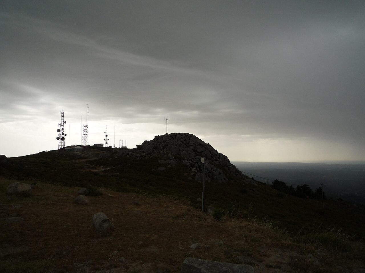
Fóia — Highest Point in the Algarve
At 902m, Fóia is the highest point in the Algarve — the summit of the Serra de Monchique, with 360° views from the Atlantic coast to the Spanish border. Drive to the top, or hike from Monchique town.
Rocha da Pena
A 479m limestone plateau rising out of the Algarve's interior, with a 4.8 km loop trail past wildflower meadows, vultures overhead, and 360° views. One of the best short hikes in the Algarve.